Friday 1 June 2012

Elegant Lisbon Running Route

Click here for route map 
Length 6.9 km (4.3 miles), terrain has one gentle hill climb

Lisbon Running Routes:
Best Lisbon Running Routes: Overview
Park of Nations (Oriente)
Ancient Alfama  
Elegant Lisbon Downtown  
Belem World Cultural Site  
Cool Bairro Alto
   

For other running routes, see the Route List

Over the years, I've traveled to Lisbon a half-dozen times, and each time I immediately pointed my running shoes up the hills to the east or west of the town center. The narrow alleys and stairs in those ancient neighborhoods, the Alfama and Bairro Alto, always captivated me, and I never once just ran the downtown valley between them.
News kiosk along Avenida da Liberdade
But this time, I took another look, and decided I'd run up the valley one evening, starting downtown at the main Praça do Comércio (commerce square) at the river, heading northwards through the Baixa (downtown) and running the gradual uphill grade out Avenida da Liberdade and then up the small hill at Parque Eduardo VII.

NOTE: see the Destinations Tips page for tips about spending your free time in this great town!

There are some nice aspects to this particular run: its rise of only about 80 meters over 3.5 kilometers is very mild by Lisbon standards. And even better, this run passes through the most elegant neighborhoods of old Lisbon, full of old-world charm.

Standing there at the Tejo River, looking across the wide expanse of the Praça do Comércio, and the classical arcaded buildings lining the square, you are viewing the results of the reconstruction scheme after the devastating earthquake of 1755. 
Praça do Comércio with graduating students getting their black capes
The quake destroyed the city back then, and the town was rebuilt to a design by the Marquês de Pombal, who also laid out the square. The square has been undergoing refurbishment for years now, but the construction seems to be just about finished, as of this posting.

So, now that you've taken a look around, let's head straight through the giant archway at the north end of the square and head up Rua Augusta. This is the only pedestrian street in the Baixa, and is lined by the neighborhood's most lively shops and restaurants. Like almost this whole route, the way is paved in typical Portugese black-and-white stone mosaics in beautiful designs.
Rua Augusta in the Baixa
The parallel streets seem a bit lifeless and shabby in comparison. At Rua de Santa Justa, look left to see the old iron elevator tower to take people up to the Chiado neighborhood on the hilltop. The tower was built by Gustave Eiffel, who also built the Eiffel Tower.

You will come out into another major square, Rossio, whose wavy mosaics recall the tsunami that hit the town after the earthquake. Up the hill to the left, you can see the ruins of Carmo, a church that was never rebuilt after the quake.
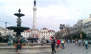
Rossio
The north end of the square is dominated by the national theater. Run around the left side of the theater and past the main train station (also called Rossio), and into the next square, the Praça dos Restauradores. The art-deco Eden Theater on the left has a great rooftop garden with palm trees.

Just past the square, the Avenida da Liberdade begins, the most elegant boulevard I've ever seen. It has 8 rows of trees and lush tropical gardens lining each side, with ponds, statues, cafés, kiosks and monuments adding just the right accents. 
Liberdade landscaping
This is the way every great avenue should be, the way I had expected the Champs-Élysées in Paris to be, but wasn't.
Mosaic, typical Lisbon sidewalk
The route has been flat until now, but it begins its slight uphill climb now, which will continue until you reach the turnaround point. Liberdade ends at the very busy Marquês de Pombal square, with a huge statue of Pombal in the middle of the traffic circle. You'll have to cross several streets to get to the park on the other side, Parque Eduardo VII.

You can just continue on up the central promenade towards the twin white columns marking the top of the park at the north, or follow my route along the right (east) side, up and over the wooded hill. This way has all the climbing right at the beginning, then flattens out past the gardens and café at the top.
Parque Eduardo VII, view from the top
At the top of the park, cross the street (Avenida Cardeal) behind the two white columns and run up along the semi-circle behind it to get a great view out several directions, especially back over the way you just came. This is the turn around point.

Now just continue running parallel to the way you came, back along the west side of the park, where you go by one of Lisbon's several botanical gardens.
In the botanical garden
Just run back along the other side of Liberdade and back to the starting point.
Crossing Pombal on the return trip

Tuesday 29 May 2012

Stuttgart Rosensteinpark Running Route

Click here for route map 
Length 3.3 km (2 miles), terrain contains one hill

Stuttgart Routes List:
Best Stuttgart Running Routes: Overview
Schlossgarten Park  
Rosenstein Park  

TV Tower hills  
Bärensee lakes  
Vineyards  

Stuttgart Airport woods
For more running routes, see the Route List

Here's a nice little route down near the Neckar River in Stuttgart. You can either add it onto the Schlossgarten route, or just run it by itself.

NOTE: I did this route combining it with a run down the river from Gaisburg, at the big gas tower. I crossed Talstraße bridge and then headed northwest along the north bank of the river, first running next to the Mercedes test track (I waited around, but didn't see any prototypes drive by that evening) and then by the Wasen, the site of Stuttgart's yearly spring beer festival.

Starting point at the Schlossgarten ponds
If you want to run it by itself, you can easily get there on the U-Bahn, getting out at the Mineralbäder station by taking either U-Bahn lines 1, 2 or 14. We'll start this run there.

NOTE: see the Destinations Tips page for tips about spending your free time in this great town!
 
From the station, turn northwards and head into the Schlossgarten park. You'll come to the last two little ponds at the east end of the park. Just turn right and head past the last pond and then follow the path as it curves uphill towards Rosenstein Palace, to the left.
Rosenstein Palace
Rosenstein Palace and the grounds were built in the 1830s as a summer palace for the King of Würtemberg. Soon afterwards, one branch of my own family left Würtemberg to emigrate to America. Now the building is used as a natural sciences museum.

There is a nice rose-garden next to the palace. Run past the building, then turn right to begin a counter-clockwise loop around Rosensteinpark. From here, the main path is paved and heads northwest.

In Rosensteinpark
The park covers a hilltop, sharing the east edge with Wilhelma, the city zoo. Wilhelma is one of Germany's oldest zoos, which began life as a royal menagerie in the Rosenstein gardens. You can run right along the zoo fence along the east edge of the park, going by polar bears and camels.
Camel in Wilhelma
The middle of the park is an uncut meadow.

When you get towards the north end of the park, the main path curves towards the left, towards another group of modern buildings belonging to the natural sciences museum, and a playground.

Now the path will curve southeast, back towards the Schlossgarten. When you get back near the palace, take a path curving downhill along the right. It will go past the old guardhouses and on down to the ponds again where you started.