Showing posts with label Europe. Show all posts

Monday, 21 February 2022

Lucca Ramparts Running Route

Click here for route map

Length 4.2 km (2.6 mi), terrain: flat, gain 11 meters.

I like Lucca. It's my favorite Tuscan town to visit. Of course, it lacks the spectacular sights of Florence, with that city's Michelangelo statues, amazing palaces, world-class Uffizi art museum, imposing squares, and the Ponte Vecchio bridge lined by old houses. And, of course, Lucca doesn't have Pisa's awesome leaning tower. And, of course again, Lucca is definitely topped by Sienna's impressive Piazza del Campo square, with its Palio horse races twice a year.  

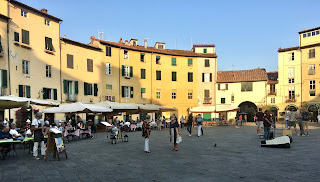
Piazza del Amfiteatro
Lucca's Piazza del Amphiteatro: a great place to eat!

But those towns are also totally overrun by tourists. A typical visit nowadays means shoving your way through packed crowds, being jostled by pick-pockets and being overcharged for everything you consume.

Lucca has its tourists too, but they haven't reach tsunami levels yet.

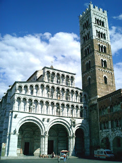
Duomo
The Lucca Duomo (cathedral)

Lucca hits that sweet spot: it's great, but not quite spectacular. Its churches and squares are beautiful and full of Italian craftmanship, but nothing is leaning precariously, and Michelangelo never got any big public commissions there. It's just an ancient town full of winding lanes lined by medieval buildings, beautifully crafted churches and palaces, and an oval square (Piazza del Amfiteatro) built inside an old Roman amphitheater. And to top it off, it's all surrounded by an intact defensive wall around the whole old town. 

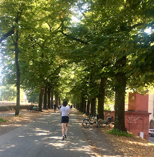
The ramparts are Lucca's most popular running route

The wall -- more a thick earthen rampart -- is Lucca's unique selling point among Italy's myriad amazing towns. And up there, on top of the ramparts, it so happens that you'll find all the city's runners, following the best running route in town.

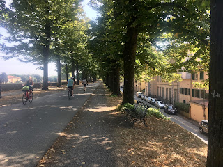
The rampart paths are lined by trees, providing lots of shade in hot weather. And the quiet, green surroundings, the constant views into the old town's maze of alleys and out into the surrounding parkland outside the ramparts, make it a scenic and pleasant place to be out and about.

Occasional highlights -- Lucca's palaces, gardens and churches -- keep it interesting. And the total lack of traffic and intersections make it a pleasure to follow.

Another positive result of the loop is, of course, it's impossible to get lost up there. Just slip into cruise-mode, follow the wide path, and do one, two or as many 4.2-km laps as you feel.

You can also get on or off at any number of access points. There are city gates with ramps to get down to street-level at each of the four compass coordinates: north, south, east and west, plus a few more ways down along the way.

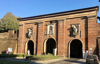
So, if you're ready to take my advice -- to slip on your running shoes and head out for one memorable run -- just find one of those four gates in the walls. This route officially starts at Porta Santa Maria, the northern gate, but you could start anywhere. 

Start here at Porta Santa Maria

Just run through the gate into the old town, and immediately take one of the two ramps leading upwards to either side. Once you're up there among the people strolling the path and hanging out on the benches,(the path is called Via delle Mura Urbane), off you go. I've written up this route to follow the walls going clockwise, with the old town to your right, but that doesn't really matter, either. But most runners up there seem to be heading that way around. 

Along the shady ramparts

You'll quickly pass the first of many bulwarks built outwards from the walls, protecting them with ways to shoot sideways at anyone trying to breach the walls. They provide interesting views and are often adorned with statues, monuments, old cannon emplacements, playgrounds and even cafés.

At the second bulwark, the wall turns right and you start running along the eastern side. Just after the 1-kilometer mark, you come to (and run above) the eastern gate, Porta Elisa.

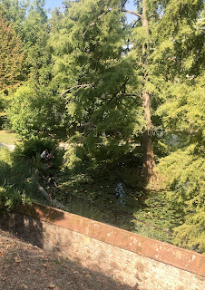
One of my favorite views comes at about the 1.5-km mark, when you pass the botanical garden (Orto Botanico) on the inside of the walls. Very lush and peaceful looking, full of huge cedar trees! You are now running westwards, along the south side. 

View of Orto Botanico

There are a couple of inviting cafés along this south wall. At the 2-km mark, you'll also run by the back side of the cathedral, the Duomo di San Martino, with its square tower. All in all, this south side a great hangout to come back to later. 

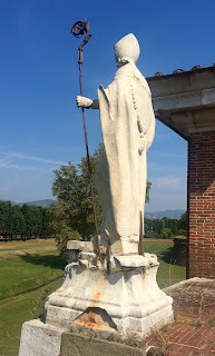
Statue along the west side

The walls gradually turn northwards as you run along the west side. The western gate, Porta Santa Anna, comes up at the 3-km mark. There are a couple of museums in old buildings right along the walls here, one in the old mint (Museo della Zecca) displays old Luccan coins and minting machinery, and the other in the old cavalry stables (Cavallerizza) hosts a lively variety of art exhibits, forums, workshops and festivals.  

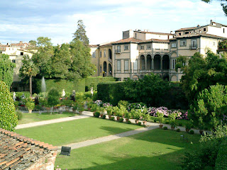
Palazzo Pfanner gardens

Once you are back on the northern wall, at the 4-km mark, you'll pass the last highlight: the view into the formal gardens of Lucca's most famous palace, Palazzo Pfanner, now a posh hotel.

You'll soon be back at the starting point at Porta Santa Maria, where you can head home or start lap number two, as you please. Just make sure you don't over-do it: save enough time and energy for exploring and enjoying Lucca's many other delights within the old walls!

Thursday, 3 December 2020

London Embankment Running Route

Click here for route map

Length 10.7 km (6.6 mi), terrain: flat and easy (gain 48 meters), some steps and loud intersections

One of my favorite places to be in London is along the Thames. The river is the city's streaming heartblood, flowing by as a constant witness to all the great events, people and places that grace its shores. 

View of the Shard with a Thames-side pub crowd

So, for me at least, there is nothing like taking a run along the riverside trails along both banks of the Thames. The embankments are lined with monuments, theaters, wharves, pubs, museums and almost everything that contributes to London's rich culture. And the network of bridges lets you switch from side to side at regular intervals. 

Along the Thames

This running route will explore the city center, passing a lot of the tourist spots that make London such a world-class destination. We'll start out in front of the Houses of Parliament, next to Westminster Cathedral, then cross the river to follow the south bank, past the London Eye, the Waterloo venues of the Royal Festival Hall, Queen Elizabeth Hall and the National Theatre, head past the Oxo Tower, the Tate Modern Art Museum with the Millenium Bridge, the recreated Globe Theatre, the replica of the Golden Hinde exporation ship, Southwark Cathedral and City Hall before crossing the legendary Tower Bridge.

Then, running home on the north side of the river, we'll loop through the marina in the old St. Catherine's Docks basins, and return to Westminster by way of the Tower, Custom House, passing St. Paul's Cathedral and Temple Gardens, running through graceful Embankment Park and then back to the start.

There are lots of other sights along the way: this is truly a run to remember, full of Victorian charm. The only downside is that there can be -- and probably will be -- big crowds of walkers in different sections. But 90% of the way will be stress-free, so I think it's well worth it. Otherwise, just slow to a walk when needed, and go with the flow and do a bit of people-watching. 

Oliver Cromwell statue at Parliament

So if you're ready to go, get yourself to Parliament Square, with the statue of Winston Churchill looming cantankerously above, and the main entrance to Parliament across the street. The Big Ben clock tower is right there, and Westminster Cathedral is off to the south, with the undulating Gothic facade of the Lady Chapel facing Parliament (and inside it's even more amazing, with an intricate laticework of stone artistry up in the vaulted ceilings).

Once you can tear yourself away from this fascinating spot, head past Big Ben and across Westminster Bridge to southern London on the other side of the river. We are already beginning some of the great riverside views which will accompany us for the whole run: Parliament itself reflected in the flowing water and the County Hall and the London Eye wheel across the way. Run on either side of the bridge, whatever looks more interesting to you. 

Running towards the London Eye

At the other side, take the steps down to the riverside trail and head northwards right at the riverside. You're now passing the County Hall building, which nowadays houses the aquarium and a lot of tourist attractions. We're following the Queen's Walk.

Now you run under the supports for the Eye, which barely moves in its half-hourly rotations.

And then, at the 1-kilometer-mark, you run beneath the Hungerford railroad bridge, with its modern footbridges added to each side, which connect people to Charing Cross on the other side.

The three theaters now come up as we approach Waterloo Bridge. They offer cafés, free afternoon entertainment in the lobbies and rooftop dining in non-corona times, and are worth coming back for a visit. Various food stands and pubs dot the trail around the square at Gabriel's Wharf

At Gabriel's Wharf

At the 2-kilometer-mark, the Oxo Tower will be visible coming up on the right: it's gone through a few incarnations, first as a power station, then as the Oxo beef-bouillon factory, and now it's a mixed-use place with stores, restaurants, a hotel and flats.

You should also be able to see the dome of St. Paul's Cathedral coming up in the distance across the river. Then you head under the Blackfriars car-bridge and then the railroad bridge.

Now comes the looming edifice of the Tate Modern Museum on the right, with its huge wall of dark bricks. It's another ex-power plant. The modernistic Millennium footbridge connects the Tate to the cathedral on the other side, making both much more accessible to walkers. Nice idea! 

Millennium Bridge, looking towards Tate

Shakespeare's Globe Theatre comes up right after that, with its Elizabethan theater architecture.

Now come a couple of more bridges: Southwark and Cannon Street railway bridge at the 3-km-mark. The trail leaves the river for a few blocks at the Anchor pub, along the narrow lane of Clink Street before you come to the replica of the Golden Hinde. The tiny ship, commanded by Sir Francis Drake, was the first English ship to circumnavigate the world, while raiding Spanish shipping along the way. The resulting treasure was brought back to England, starting the long process of Britain wresting control of the world's seas.

You now continue away from the river for a short way as you circle around the back side of Southwark Cathedral, a beautiful old church from the inside. Right behind it, at the railway viaduct, is one of my favorite markets: Borough Market, with lots of gourmet food to be found, of every variety. I used to work in the area, and it was a great place for lunch, open 6 days a week. And a few pubs line the back side to add a good English ale to the menu.

Now you run up the stairs and cross the busy A3 road at London Bridge, where the soaring knife's edge of the Shard building dominates the skyline. Run towards the bridge, then run down the stairs at the water's edge to the right to continue at the riverside.

Finally back along the water, the skyscrapers of the City of London glitter across the river. In 200 meters, I like to take a quick detour into the Hays Galleria, an ex-wharf where ships once pulled into a tidal-free basin to load and unload. There is a cool, weirdly whimsical sculpture group in the middle of the hall, the Steampunk statue. I'm always fascinated by the strangely British maritime characters.

Then continue running past the HMS Belfast cruiser, an impressive World War II beast, with the medieval Tower of London fortress across the river. We're now passing modern office buildings and the globe-shaped City Hall on the right side, a favorite hangout for all the office workers in the neighborhood.  

The Tower Bridge

And now we've finally reached it: the halfway point, time to cross the river at the iconic Tower Bridge, maybe the most photogenic bridge in the world.

Cross under the bridge and go up the steps to get onto the east side of the bridge, heading across the water. Take a close look at this gem of Victorian engineering, with its Gothic towers hiding the drawbridge-raising machinery, and iron links suspending the bridge below. 

Girl with Mermaid fountain

When on the other side, take the steps down to the ground level and we'll take a short detour to the east, past the Tower Hotel and the Girl and Mermaid fountain to take a quick tour of St. Catherine's Docks. This old dockyard has been restored into a modern marina, but still has its Victorian buildings and boat-locks. It's a quiet, relaxed oasis in the middle of this big city, at the 5-km-mark. 

At St. Catherines

Just circle the first of the 3 basins by running around the right side, past the Dickens Inn and all its flowers, then take the narrow foot bridge, run past the yachts to the Starbucks in the round temple, then head back out to the Tower Bridge the same way that you came in.

Running westwards, head under the Tower Bridge as we pass right by the waterside stone walls of the Tower, another relaxing spot. 

Gate at the Tower

Luckily, the modern buildings just past the Tower have included new foot-trails along the water, so a detour away from the river is no longer necessary here.

We'll soon pass the tree-lined grandeur of the old Custom House, and continue under London Bridge. The next section of the trail passes some waterside pubs, and if you're there in the early evening, they're full of business-people from the City, drinking a few pints with their colleagues after work. 

At Custom House

After passing under Southwark Bridge, you'll have to detour away from the water for the last time, as the path goes around the old harbor at Queenhithe. The quay goes back to Roman and Saxon days, although it just looks like a mudflat now. At low tide, people search the muck for treasures and flotsam. 

People treasure-seeking at Queenhithe

The trail rejoins the river at Paul's Walk, near St. Paul's Cathedral. You'll run under the Millennium footbridge again. 

At Paul's Walk

Back at Blackfriars Bridge, we're at the 8-km-mark. The section ahead is my favorite part of the route. Although we are now up at street-level for busy Victoria Embankment Road, there is a riverside promenade with the winding-fish streetlamps and with monuments and historic ships docked up for the rest of the way.

We'll pass the interesting legal complex in the Temple Gardens across the street, where jurists still (occasionally) run around in their powdered wigs.  

Along Victoria Embankment

Just before Waterloo Bridge, at 9 kilometers, we pass the stone elegance of Somerset House, originally built to bring a variety of Royal Navy offices under one roof, the first dedicated military office building in the world.

When we get to the Egyptian obelisk, Cleopatra's Needle, let's backtrack a few meters to leave the river for a short bit, crossing the street into Embankment Park. This charming slice of greenery has everything you need in a city park all packed into one compact space: monuments, flower beds, benches full of relaxing office workers, the ancient York Watergate, once the bishop's way down to the river from his palace.  

In Embankment Park

Behind the gate, you'll pass the outside seating for Gordon's Wine Bar, a fascinating old bar located in a vaulted-ceiling cellar.

At the west end of the park run right into the entrance to Embankment Tube Station (crowded!) and out the other side to cross Victoria Embankment Road again and to continue westwards under Hungerford Bridge and towards Big Ben.

We'll pass Scotland Yard at the 10-km-mark, and then other government buildings and more war monuments and historic ships.

At the Thames Clipper dock (I recommend you take them to Greenwich sometime!) the steps take you back up to Westminster Bridge, with Parliament and Big Ben right in front of you. Now just run back out to the square to your right and you've finished this amazing run!

Sunday, 11 October 2020

Amrum Island Running Route

Click here for route map 

Length 4.6 km (2.9 mi), terrain: flat but sometimes hard-going through the loose sand, gain of 10 meters

NOTE: If you're staying in nearby Norddorf, you can run along the quiet road through the marsh from the village, or along the dike, further east. This will add 2.3-kilometers in each direction to the run.

Amrum is my favorite German North Sea island: A varied landscape, small enough to easily explore on a bike but with a few scenic villages and sights. There are windmills, the lighthouse, thatched-roof houses everywhere, a long ridge of dunes running the length of the island, wide (often deserted) beaches that seem to go on forever, and strips of woods, heather and marsh. You won't find a big hotel anywhere.

Typical Amrum, in the village of Nebel

And one of the most natural spots on the island is the narrow northern point, the Odde or also called the Nordspitze. The whole peninsula is a nature preserve, with long, lonely coasts to either side. It's a wistful place of hikers, runners, birdwatchers and shell collectors. It's a place to re-learn how to wonder.

Runner along the Odde

Like the whole island, the west coast is lined by a wide beach, and the east coast is swampy, submerging into mud flats (the Watt) that stretch to the next island, Föhr. Guided groups of hikers gather at the start of this route to cross the flats at low tide, walking barefoot and in shorts through the occasional deep trench.

There's also a bird rescue station in the reserve, which can be visited by making a reservation in advance.

But right now, we want to just get out in the wild surroundings, breathe the salty air and bathe in the glory of Mother Nature.

We'll start at the beginning of the preserve, about 2.3-kilometers north of the village of Norddorf. There is a parking lot for bikes there, and a map of the island on a board, a meeting point for guided hikes (Treffpunkt). This is on the eastern side, facing the mud flats. 

The start: bike racks and map

The route itself is simple: just head north to the point, then head back again down the west coast and its wide beach.

A dirt road heads north for the first couple of minutes, but then ends at the water's side. The dunes of the preserve are fenced-in from now on. You just run in the sand, heading north, along the water. You can see Föhr just a few kilometers to the east. 

Along the east shore, with Föhr to the right

I like running as close to the water as possible: it's simpler to run on the wet sand than on the loose, dry sand close to the fence. Depending on the tide, you might be able to run quite a way out on the mud.

Group of hikers walking across the mudflats to Föhr

At about the 1-kilometer mark, you'll pass the bird rescue station, which you can't really see, hidden up in the dunes.

At 2 kilometers, you'll come to the northern point, where you cross the dune and then the wide beach to begin running south. Again, depending on the tide, you might be able to run further out during low tide.

Northern point of the island

This side has a whole different feel from the mudflats: here are waves breaking on the beach, with piles of shells that collect in low spots. This side is more exposed to the wind.

The wide west beach

After 4 kilometers, start watching for the sandy path that cuts through the dunes to get you back to the starting place. There is a green-and-white nature-preserve sign there, and lots of footprints leading you into the dune.

Path cutting across the dunes

NOTE: You could also continue southwards along the beach if you want to get back to Norddorf: you can see the buildings of beachside restaurant at Norddorf Beach straight ahead.

The beach gets more active around here. The Norddorf surf schools drag their equipment out the the water here for classes, which are fun to watch.

Windsurf class for kids on the west beach


Tuesday, 30 June 2020

Schlei Fjord Running Route

Click here for route map

Length 7.2 km (4.5 mi), terrain: a few short ups and downs on a flat trail, gain of 0 meters

It's not well-known internationally, but several fjords cut their way into the northernmost German Baltic coast. And one of the nicest fjords is the Schlei, a 42-kilometer-long inlet stretching southwest from its mouth on the Baltic at Maasholm.

Unlike the steep, mountainous fjords in Norway, those in Denmark and Germany are nestled in sandy hills, dug out by ice-age glacier tongues, or by their melted runoff. The Schlei can seem as wide as an ocean and as narrow as a small river, lined by pastures and woods, dotted by sand cliffs and manor farms.
Along the Schlei

This route follows part of the Schlei's southern shore, along the Schlei Wanderweg, a hiking trail that lines several sections of the inlet.

This running route connects two fjord-side manor farms, Büstorf and Stubbe, near the scenic towns of Rieseby and Sieseby. It follows a very quiet section of the Schlei hiking trail, with several secluded beaches and a lot of nice lookouts over the fjord, then returning on the same trail. It's an inspiring place to be out and about!

We'll start the run at the Büstorf end, as there is a public parking lot there. At the Stubbe Manor end, you have to park further from the trail.
The carpark in Büstorf

So, if you're ready to get going, the turnoff to Büstorf is along the road from Kosel to Rieseby, just a half-kilometer southwest of Rieseby. There is a parking lot for hikers.

Now just continue north on the road the short way to the shore, and from then on northeastwards past the little marina (Wassersportverein Rieseby).

From now on, there are no more buildings or roads until we reach the Stubbe manor. The first part of the trail, directly at the water's edge, is a bit rough, with swampy spots and some deep sand.
Waterside running

It then gets a bit higher and dryer, heading into beech woods and meadows. Out over the water, sailboats cross the glittering reflections.
A little swimming spot

You'll pass a few first secluded swimming spots, and a place where people balance stones into little pyramids.
The stone pyramids

After 1.5 kilometers, for the next 500 meters, the waterside trail starts taking some steep ups and downs, and there is a spot with a huge fallen beech tree blocking the path. To avoid those, you can follow the nicer path as it goes through the woods, parallel to shore, but inland a bit. Or you can take the challenging shore path, which is what is followed in this route map. I like this route best, with more water views, creek crossings and secluded inlets.
Crossing a stream without a bridge

You'll then head back into woods for the rest of the way into Stubbe. The Stubbe farm is beautiful, and you might want to take a turn to the left to see it. There's a cafe there, too.
The gate-house to the Stubbe mansion

This is the turn-around spot. Now follow the same waterside trail back to the parking lot in Büstorf.

Vikings on the Schlei

There are a lot of Viking remains in the area, especially at the west end of the Schlei, near the main town of Schleswig. There is the archeological site of Haithabu (Hedeby) on a little side-arm of the Schlei. Haithabu was an important Viking trading town, where goods were unloaded from Baltic ships and carried westwards over land to the Eider River, where it was again put on boats and shipped out to the North Sea. Some of the Haithabu buildings have been rebuilt on their original locations, and local people reinact some of the village inhabitants, exhibiting their crafts. There's also an interactive museum. Check for more details here.

And starting in Haithabu, a long earthen wall, the Dannewerk (spelled Danevirke in Danish), begins, guarding the land to the Eider, much like Hadrian's Wall did in Britain. It was built to protect Denmark's southern border from Saxons and Slavs encroaching from the south and east.

You can also find several big stones carved with Viking runes in the area, and a few were moved to the Haithabu museum. Enjoy your stay!

Friday, 15 May 2020

Budapest Danube/Buda Hills Running Route

Click here for route map

Length 12 km (7.5 mi), terrain: as the name says, hilly!, gain of 243 meters

NOTE: You can save 2km and the steep climb up Gellért Hill by crossing the Elizabeth Bridge and running directly to Buda Castle.

I didn't have a camera with me when I ran this, so I used pictures from Google Maps Street View. Thanks Google!

In most European cities, you can't go wrong running along the riverfront. Budapest is another of those towns, and it has the advantage of lining the majestic Danube. And even better, many of the city's best sights are located at, or just off, the river, and among the neighboring hills.
Danube view from the Buda Palace
The Danube, powerfully flowing through and separating Buda (with its hilltop castles and old town) from Pest (on the east side, with the downtown) is lined by historic, stunning buildings and crossed by one of the world's most scenic bridges. You'll run by the gothic fairy-tale of the Parliament building, climb up two hills, through castle ramparts to a fortress and to the huge old Habsburg palace, and end up crossing a quiet garden of an island.

My first trip to Budapest was in the 1990s, not long after the Iron Curtain came down, and much of the city was still waiting to come back to life after 50 years of neglect. Almost all the facades in the Terézváros and Erzsébetváros sections of the new-town (okay, it was new in the 1800s) were half crumbled-off, and when I wandered into apartment courtyards I'd be surrounded by a forest of pine logs that were provisionally jammed up under the wooden walkways above to keep them from collapsing into the yard.

Now the city has moved on and rejuvenated itself, and it is no longer a sad echo of its elegant old self. The same neighborhoods which were once decayed ruins are now pulsing with life, full of shops and restaurants. Although there are still lots of crumbling facades, they just add a funky flavor to a vibrant mix.

NOTE: Just a notice about running along the Danube: the riverside isn't exactly pedestrian-friendly. On the eastern shore (downtown), a tram-railway parallels the river, along with a street. Sometimes the best place to run (quieter, greener) is a bit away from the river, on the far side of the railway. And sometimes it's better on the river-side of the railway. And at other times it's better run right next to the water. But there are sections where the waterside sidewalks disappear and you have to cross back across the street. No big problem: just take the sidewalk that appeals to you best for that section of the river. I like boats, so I try to stay at the water's edge as much as possible. On the Buda side of the river, there is also a tram-railway, and a road hugs the riverside for the whole way, so you have to take the sidewalk between the tram tracks and the river road, following the tree-line. Good thing that we're up visiting the hills for most of that side of the river!

So let's head out to discover some of the nicest parts of town, down by the Danube and up into the Buda hills. We'll start the run at Szabadság tér (Liberty Square), just a couple of blocks east of the river, in the Lipótváros neighborhood, the downtown. Standing there at the Soviet war memorial, the square is surrounded by elegant bank headquarters buildings.
Liberty Square, start of run
To get moving, leave the square to the northwest, along Vécsey utca (utca is, of course, "street").  This takes you in one block to the square behind the stunning, gothic Hungarian Parliament building. 
At the Parliament
Now turn left and run along Kossuth Lajos tér (tér means "square") to the river, a block to the west. There are zebra-stripes to cross the busy shore road, "Id. Antall József rkp." This is one of the few easy spots to get to the water, as the railroad tracks run underground at the parliament and don't block the way here.

So now we turn south and enjoy the Danube riverside.
Shoes along the Danube
In just a block, you'll pass a sculpture of metal shoes lining the shore. This marks the spot where some unlucky very Hungarian Jews were executed and pushed into the river by fascists during the last phase of World War II, just as the Soviets were about to enter the city and liberate them.

Continuing, this is one of the nicest parts of the riverside, with bushes and trees, a bit away from the street. You can see the two hills across the river in Buda, where we'll run on the way back.
The eastern shore, with view of Buda Castle
In a few blocks, at the 1-kilometer mark, we'll come to a main highlight of the run, the chain bridge (Széchenyi Lánchíd), a 180-year-old monument to the technology of the industrial revolution. If the chains look familiar, maybe it's because there are similar ones on the Tower Bridge in London. Little wonder, because it was a British engineer, Clark Adam, who designed this beautiful bridge. I like to run out to the middle of the bridge, to view it up closer, and to get a great view of the river. You might want to try it. Then run back to the Pest shore to continue running southwards.
Chain Bridge with Buda Castle to left
You can see the domed roof of the castle, the old Habsburg palace on the hilltop directly across the river.

The shore road now changes its name to Jane Haining rkp., and the nice riverside walkway gives way to a narrow strip between the street guardrail and the water's edge, with lots of riverboats tied up here. There is a nicer sidewalk with some parkland off to the left, on the far side of the train tracks, if you prefer.

We'll then go under a modern suspension bridge, the Elizabeth Bridge (Erzsébet híd) and keep heading south.
View to Gellert Hill
We're now passing the second hill (Gellert Hill), even higher than the first, across the river. You can see the massive fortress perched on its ridge, and the freedom monument rising above it. The fort was built by the Habsburg kaiser following the 1848 revolution, to prevent further uprisings in Budapest.

After passing more riverboat docks, at the 3-kilometer mark, you'll approach the beautiful Liberty Bridge (Szabadság Híd), another Nineteenth Century iron bridge.

This is as far south as we'll go: we'll cross over to the Buda side now. But before we do, notice the palace just south of the bridge containing the Corvinus University. And behind it is another beautiful Victorian-era structure, the iron-and-glass market hall (Nagy Vásárcsarnok). Make sure you take the time to wander around it and its hundreds of interest little stands while you're in Budapest!
Crossing Liberty Bridge, Gellert Hill to right
Take a look at all the ornate ironwork on the bridge as you cross, crowned with mythic turul birds on the towers.

As we approach the other side, you can see the cliffs, topped by a cross on the south end of Gellért Hill. That will be our first sight on the run up the hill. And notice to the left, the huge, palace-like Hotel Gellért and its beautiful baths elegantly gracing the riverside.

Cross the riverside road and the tram tracks at the zebra stripes and continue straight up the ramp-like sidewalk under the cliffs to your right. We'll be heading uphill for a while (a 120-meter gain), from now on! The whole hill is full of zig-zagging trails, and it really doesn't matter much which ones you take, as long as you keep going upwards to the Citadella (fort) at the top.

At the next junction turn right to run a few steps to the chapel built into the caves in the cliff face. This was once the home of a hermit monk who treated people with healing spring water from the cave. Later, a chapel was built there, and a real bath.
Gellert Hill trail
But we're just looking from the outside, so now turn around and run back a few steps until the first trail going uphill to the right. The hill provides a refreshing dip into nature: it's wooded, and we'll stay on the steep side overlooking the river as it heads uphill. Mostly, the trails are paved ramps, but in some spots there are steps. In the steeper spots, I just switch to walking, which is still workout enough for me.

There are occasional spots with viewpoints along the way, which are good chances to catch your breath.

When you finally reach the southeast corner of the Citadella, you'll enter a paved terrace with a Hungarian freedom monument. There are also great views to every side here.
Freedom Monument at the Citadella
Now continue along the flat trail behind the monument and to the right, following the north wall of the fortress. Outside the main entrance, there are stands set up selling food, drink and souvenirs. You have to buy tickets to go inside the fort.
Main Gate at the Citadella
After a last look out from this great viewpoint, take the steps down, across from the main fort entrance, and then the path to the right. This runs into the Citadella Lejtó trail, where you turn left and follow it all the way down the hill to the river at the Elizabeth Bridge.

There are a few roads coming together there, you need to take the zebra stripes over to Döbrentei Square, a circular park with a statue of Empress Elizabeth (the ever-popular Sissi). This is the 5-kilometer-mark, and we're next to the river road.

Now exit the park to the north, running under the overpass, cross the tram tracks and a street and continuing straight into Döbrentei utca.

We now run north, past a few little museums and hotels, and cross Ybl Miklós ter at the History Museum, with some statues of World War I soldiers out front.

Continue north along the ornate walls of the castle gardens. We're almost ready to head up the second (and last) hill to the palaces and the old town of Buda on the top. Luckily, this hill isn't very high.
The Palace Bazaar: head through that archway!
When you come to the Várkert Bazár (castle garden bazaar), turn left to run through its ornate archway to take the trail zig-zagging up the hill through the gardens. This is the 6-kilometer-mark, half-way home. This uphill section isn't so steep and only gains 60 meters.

Keep to the left as you run uphill below a little round fort, the Rondella. When you can get a good view of the fort, take the path going straight up to it, then keep on the path to the left.
Way into the palace walls
You'll run through a gate in the castle wall next to the round tower, and find yourself in a courtyard next to the National Library. Now turn right and run out the other gate in the wall, and then follow the path to the left as it follows the outside of the castle wall.

This will take you right up to the courtyard in front of Buda Castle, a spectacular palace where the Habsburg kaisers resided when they were in Budapest in their role as Kings of Hungary. The palace was badly damaged during World War II, and it was rebuilt in a simplified style. There are various museums and libraries in the buildings nowadays. The place looks magical all lit up in the evenings.
Terrace in front of palace
So now, while we're up here on the hilltop, we'll want to explore some of the inspiring scenery in the nearby old town.

So continue running northward, past the main palace, quickly coming to the next one, Sandor Palace, still used by the Hungarian government as residence of the Hungarian President. There is an hourly changing of the guards, which you might see if you're there at the right time (on the hour, until 5 p.m.).
Sandor Presidential Palace, with guards
Now continue northwards and into Disz ter in the old town, following this street past the old houses and get a feel for this charming hilltop town.

In a couple of blocks you'll come to the beautiful Gothic St. Matthias Church (Mátyás Templom), a church which has been built and rebuilt for ages. We'll now loop through the next neighborhood to come back here in a few minutes.
St. Matthias with Holy Trinity column
At the baroque Holy Trinity statue (erected to commemorate the ending of the plague, run northwest along narrow Országház utca, lined with old homes and mansions.

When you come to the ruins of Mary Magdalena Church (a former Franciscan monastery, bombed-out in the war), turn right onto Nándor utca. Then, at the National Archives, take the next right to follow beautiful Fortuna utca. (or equally nice Miháli utca) back to St. Matthias.
Fortuna Street in the Old Town of Buda
At St. Matthias, turn left and run to the back side of the church for another amazing sight: the Fishermen's Bastion (Halászbástya). This fanciful lookout with turreted ramparts was built in 1900 to celebrate 1,000 years of the Kingdom of Hungary.
Fishermen's Bastion
So now let's head downhill again, and back to the Danube. Take the exit through one of the two archways behind the church and go down the steps to the little street below. Continue with the steps crossing the grassy traffic island, then turn left onto Szabó Ilonka utca, heading downhill.

Continue for two blocks, past the yellow Catholic Gymnasium (high school), and then take the Franklin utca steps downward to the right. These end at the next cross-street, Iskola utca. Now turn left and run past a few lively pubs and restaurants, to turn right onto Markovits Iván utca.

Now run the block to Batthyány Square at the river, with the baroque St. Anna Church. This is the 9-km-mark.

Now we just cross the tram tracks at the zebra-stripes, and turn left to head north along the river again. The beautiful facade of the parliament building is right across the river.
Along the western shore, heading north
This is a nice sidewalk for pedestrians and bikes, raised up a bit over the river road to the right, Angelo Rotta rkp. The direct riverside isn't so great for running: it's often parked full with cars or you have to climb over guardrails and avoid ship bollards blocking the way.

Now just run one kilometer north to the Margaret Bridge (Margit Híd), turn right to cross the river, and we are almost home again.
Crossing Margaret Bridge, rest of run continues to right

We pass the southern tip of Margaret Island when we cross. That is a really nice, pleasant, short, flat run. Try out the Margaret Island Running Route here!

When you reach the east side of the Danube, turn right and run the few blocks south past the parliament. Run past the building to the spot where we first came to the river, then turn left, cross the zebra-stripes again and run back to Liberty Square, where we started.

It was a long, hard run, but I'm sure it was like none other in your whole life. Enjoy the rest of your stay in Budapest!