Click here for route map
Length 4.2 km (2.6 mi), terrain: flat, gain 11 meters.
I like Lucca. It's my favorite Tuscan town to visit. Of course, it lacks the spectacular sights of Florence, with that city's Michelangelo statues, amazing palaces, world-class Uffizi art museum, imposing squares, and the Ponte Vecchio bridge lined by old houses. And, of course, Lucca doesn't have Pisa's awesome leaning tower. And, of course again, Lucca is definitely topped by Sienna's impressive Piazza del Campo square, with its Palio horse races twice a year.
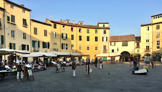 |
| Lucca's Piazza del Amphiteatro: a great place to eat! |
But those towns are also totally overrun by tourists. A typical visit nowadays means shoving your way through packed crowds, being jostled by pick-pockets and being overcharged for everything you consume.
Lucca has its tourists too, but they haven't reach tsunami levels yet.
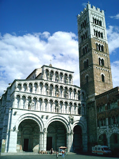 |
| The Lucca Duomo (cathedral) |
Lucca hits that sweet spot: it's great, but not quite spectacular. Its churches and squares are beautiful and full of Italian craftmanship, but nothing is leaning precariously, and Michelangelo never got any big public commissions there. It's just an ancient town full of winding lanes lined by medieval buildings, beautifully crafted churches and palaces, and an oval square (Piazza del Amfiteatro) built inside an old Roman amphitheater. And to top it off, it's all surrounded by an intact defensive wall around the whole old town.
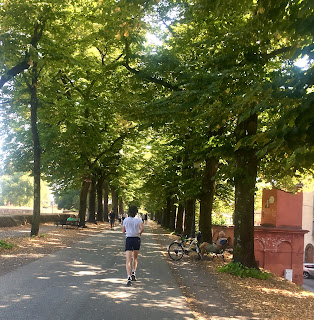 |
| The ramparts are Lucca's most popular running route |
The wall -- more a thick earthen rampart -- is Lucca's unique selling point among Italy's myriad amazing towns. And up there, on top of the ramparts, it so happens that you'll find all the city's runners, following the best running route in town.
The rampart paths are lined by trees, providing lots of shade in hot weather. And the quiet, green surroundings, the constant views into the old town's maze of alleys and out into the surrounding parkland outside the ramparts, make it a scenic and pleasant place to be out and about.
Occasional highlights -- Lucca's palaces, gardens and churches -- keep it interesting. And the total lack of traffic and intersections make it a pleasure to follow.
Another positive result of the loop is, of course, it's impossible to get lost up there. Just slip into cruise-mode, follow the wide path, and do one, two or as many 4.2-km laps as you feel.
You can also get on or off at any number of access points. There are city gates with ramps to get down to street-level at each of the four compass coordinates: north, south, east and west, plus a few more ways down along the way.
So, if you're ready to take my advice -- to slip on your running shoes and head out for one memorable run -- just find one of those four gates in the walls. This route officially starts at Porta Santa Maria, the northern gate, but you could start anywhere.
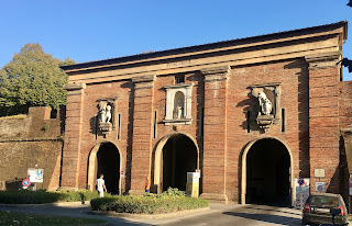 |
| Start here at Porta Santa Maria |
Just run through the gate into the old town, and immediately take one of the two ramps leading upwards to either side. Once you're up there among the people strolling the path and hanging out on the benches,(the path is called Via delle Mura Urbane), off you go. I've written up this route to follow the walls going clockwise, with the old town to your right, but that doesn't really matter, either. But most runners up there seem to be heading that way around.
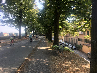 |
| Along the shady ramparts |
You'll quickly pass the first of many bulwarks built outwards from the walls, protecting them with ways to shoot sideways at anyone trying to breach the walls. They provide interesting views and are often adorned with statues, monuments, old cannon emplacements, playgrounds and even cafés.
At the second bulwark, the wall turns right and you start running along the eastern side. Just after the 1-kilometer mark, you come to (and run above) the eastern gate, Porta Elisa.
One of my favorite views comes at about the 1.5-km mark, when you pass the botanical garden (Orto Botanico) on the inside of the walls. Very lush and peaceful looking, full of huge cedar trees! You are now running westwards, along the south side.
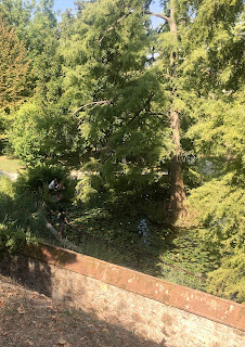 |
| View of Orto Botanico |
There are a couple of inviting cafés along this south wall. At the 2-km mark, you'll also run by the back side of the cathedral, the Duomo di San Martino, with its square tower. All in all, this south side a great hangout to come back to later.
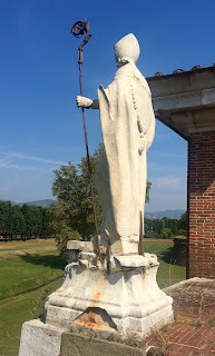 |
| Statue along the west side |
The walls gradually turn northwards as you run along the west side. The western gate, Porta Santa Anna, comes up at the 3-km mark. There are a couple of museums in old buildings right along the walls here, one in the old mint (Museo della Zecca) displays old Luccan coins and minting machinery, and the other in the old cavalry stables (Cavallerizza) hosts a lively variety of art exhibits, forums, workshops and festivals.
 |
| Palazzo Pfanner gardens |
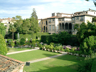
Once you are back on the northern wall, at the 4-km mark, you'll pass the last highlight: the view into the formal gardens of Lucca's most famous palace, Palazzo Pfanner, now a posh hotel.
You'll soon be back at the starting point at Porta Santa Maria, where you can head home or start lap number two, as you please. Just make sure you don't over-do it: save enough time and energy for exploring and enjoying Lucca's many other delights within the old walls!


