Showing posts with label USA. Show all posts

Saturday, 27 March 2021

Kodachrome Basin Running Route

Click here for route map

Length 2.9 km (1.8 mi), terrain: flat and easy (gain 83 meters), but with occasional bad footing, watch your step!

Utah is really blessed with natural wonders. One of my favorite spots, Kodachrome Basin State Park, is magical enough to be a national park, if it were located anywhere else. But in Utah, with its five national parks and a multitude of national monuments, Kodachrome keeps a low profile, hiding in the canyons just east of Bryce.

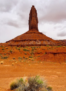
One of the many rock chimneys
 

The basin is full of rock chimneys, and lined by spectacular cliffs, with red rock foundations and white peaks rising above. Ancient, weathered junipers dot the dusty basin floor. Abundant slickrock (smooth, pillow-shaped, solid-rock hills) make for inviting climbs. It's the perfect hangout for just about anyone of any age or condition.

Juniper before the slickrock

There are a variety of trails in Kodachrome. This route follows a flat trail called the Grand Parade Trail.

This is a short and easy trail, a great way to get out and explore a bit more of the park, right near the Basin Campground. There are several other trails right there that you can combine with this to create an even longer route:

  • The short but beautiful Nature Trail
  • Angel's Palace Trail, which heads up to a plateau with views above the basin floor
  • Panorama Trail, with two different loop distances available

Audobon quote
Great quote from John James Audobon on Nature Trail
 

You can start the Grand Parade from two spots: one is just 150 meters south of the Basin Campground, or you can also start at the parking lot for the Panorama Trailhead, along the park road.

The Panorama Trail heads west of the trailhead, the Grand Parade to the east. The trail is fairly simple to follow, the trail hikers and runners have worn deep ruts along a lot of the way. There are occasional dry washes that cross the trail, and you have to find the trail again after crossing.

View near the trailhead

This route loops it counterclockwise, but it doesn't really matter which way you go. There are two box canyons along the Grand Parade: box canyon is a canyon that dead-ends into an the surrounding cliffs. Make sure to turn into and explore them along the way!

So off we go, turning right at the first junction, and crossing first one wash, then another. The trial turns left and follows along the bottom of the cliffs, rounding a promentory and then heading east again towards our first box canyon.

The palisades
 

When you reach the mouth of the canyon, notice the old wooden palisade fence that was built by pioneers to use the canyon as a natural corral. You just head westwards, straight into the narrow canyon until the trail ends, and then run back out. The canyon end is at the one-kilometer mark.

After the palisades, take the fork in the trail to the right and continue following it through more open country, past a few rock chimneys.

second box canyon
Heading into the box canyon
 

Then, after hugging some more cliffs, we come to the entrance to the other box canyon, to the right. This one is really amazing, with gigantic cliffs rising along the back of the canyon, surrounding the huge amphitheater, with their white-rock-crowned cliffs. It looks a bit like a wall of skyscrapers.

In the amazing amphitheater of the canyon

After circling it, passing the 2-kilometer mark, head back out and continue with the loop. Soon we come to the junction where the feeder trail comes in from the campground, to the right. Just keep left and head southwards back towards the trailhead, running parallel to the park road, which is 100 meters to the west.

At a wash

We cross more washes, pass lots more junipers, have amazing rock formations lining the horizon in every direction. That's one nice run!

Thursday, 21 November 2019

Skull Rock Trail, Joshua Tree Running Route

Click here for route map

Length 2.7 km (1.7 mi), terrain: several small rises, gain 29 meters

Joshua Tree National Park in the Southern California desert is one of my favorite discoveries. When I first heard about it, I imagined viewing the unique joshua trees, tree-like relatives of agave (yucca) plants. What I didn't imagine was the amazing landscape where these trees grow.
Joshua Tree runner on the Skull Rock Trail
The national park includes several areas of jumbled sandstone boulders and slickrock, perfect places for scrambling around on the rocks. There are fun and easy climbs, great views and an impressive variety of plants and animals like you can only find in the desert. And this little trail goes through one of the nicest of these areas, Jumbo Rocks.
Blooming Joshua Tree
Joshua Tree lies in the transition country where the Mohave and the Sonoran Deserts come together, with plants and animals from both regions.

NOTE: To get there, take the main park road, Park Boulevard to a kilometer east of the Jumbo Rocks Campground turnoff. There is a line of parking spaces along each side of the road at the trailhead. Go to the south side of the road to find Skull Rock and the start of the run.
This short Skull Rock Trail takes you through some of the nicest scenery, without any real climbs.

It's a short run, but the rocks give you a lot of chances to climb, scramble and explore. This is some of the most fun rock-scrambling terrain that you'll ever see.
Skull Rock: looks like Halloween!
Skull Rock itself is right next to the road, at the trailhead. Just walk a few meters towards the big boulders right there at the parking strip. There are usually other people there, taking pictures, but if you just go a few meters further into the rocks, you'll be by yourself, surrounded by walls of rocks. It's very worthwhile to take some time here before starting the run.

OK, so now that you've taken a look around, we're ready to get going. So turn southwest, with the road on your right, and follow the trail. There are occasional way-markers with direction-arrows.
Desert beauty
At first, the trail stays close to the road, but then starts curving away to the left as it skirts the big rock formations to the south.

When you see the campground down below you on the right side, take the trail down there towards the wooden message board and the outhouse.
The campground
You now turn right and run westwards along the paved campground road for the 0.5 miles through the beautiful campground. This is the life! Almost every site has its own private cliffs and rocks, and often its own joshua tree. I actually stayed at this campground, and the opportunity for further hiking/running/exploring is amazing.

When the campground road reaches the main road, cross it and turn right to follow the other half of the trail back to the trailhead.

The second half of the trail is quiet and natural, with very few people. It's my favorite part of the run.

On this half, it too follows the road at the beginning, but then turns off to the north and then follows ridges and canyons full of sand back to the start.
Along the ridge
You'll first head up and over two little ridges, then descend into the little canyon, lined by boulders and cliffs.
Great rock formations along the trail
There are signs at the end to take you back to the Skull Rock trailhead to the right side, and to combine the run with nearby Split Rock Loop Trail, which heads off to the left.

Tuesday, 29 October 2019

Tucson Saguaro Cactus Desert Running Route

Click here for route map

Length 8.4 km (5.2 mi), terrain: gradual rise, gain 127 meters

NOTE: The Sonora is a real desert: avoid the summer heat, and try to run in the early mornings. Bring water and a hat! The loop drive is open daily from 7 a.m. till sunset. It's also perfect country for a mountain bike!

When in Tucson, make sure you experience some of the amazing Sonoran Desert awaiting you outside town (assuming you're not there in the summer months!). And one of the great places to do that is in one of America's youngest national parks: Saguaro National Park. The park protects some of the densest portions of the saguaro cactus forests surrounding Tucson.
An impressive saguaro cactus
Saguaro are giants of the cactus world, rising massively like silent titans out of the sand and rock. They are pretty special beings, and are worth getting closer to. The white Saguaro flowers are Arizona's state flower, and the red fruit is a traditional food of the local Native Americans.

The park's loop drive also takes you by lots of other desert plants, like red-flowering ocotillos, mesquite trees, and other cacti like barrel-cactus, prickly-pear and cholla. It's a whole different world out in those national park hills!

There are actually two separate sections of the park, one east of town, one to the west. And each unit has a low-traffic loop drive that makes a great running trail in this little-visited park. The eastern Rincon unit loop is called the Cactus Forest Drive, and is a paved 8-mile loop (That one has the advantage of being smooth, starts at the visitor center, has more people on foot and bicycles and passes an ecology trail and some scenic rocks).

This particular run follows the shorter, unpaved loop in the west unit, the Bahada Loop. It has the advantage of having less traffic, and it's more natural, with few man-made intrusions.
Bahada Loop along Hohokam Road
The Bahada Loop is a rather rough dirt road with lots of dips and rises, circling a few small hills. It's just off Sandario Road, south of the town of Picture Rocks. The loop combines Hohokam Road on the south half of the loop, and Golden Gate Road on the north half.

The loop follows dusty Hohokam Road eastwards, heading lightly uphill for the first three kilometers. When Hohokam joins Golden Gate Road, you turn westwards and follow it downhill all the way back.

How to get there: follow Sandario Road either northwards or southwards until you hit Kinney Road, with the sign pointing to the Red Hills Visitor Center. Just 200 meters southeast of the junction, Hohokam Road heads off to the east. There's a little parking spot right at the speed-limit sign. You can also park at the Sus picnic area just a few hundred meters ahead, on the left side.

OK, ready for a desert run to remember? Turn eastwards on Hohokam Road and start moving.

You'll quickly pass the Sus picnic area on the left side, with its trail head for the Bahada Wash Trail, which parallels the road to Valley View. At just over a mile along the loop road, you'll pass the Hugh Norris Trail heading off to the right, rising into the Tucson Mountains to the southeast.
The saguaro forest
And just past the 2-kilometer mark, you'll come to Valley View, with more trailheads. There are a series of small rises to the left (north) that we will keep circling for the whole run.

During the next kilometer, the loop drive is just one-way for cars.

Enjoy the scenery. Some of the saguaros have holes in them, where birds nest. Keep your eyes open for lizards of various sizes and shapes.

At about the 3.5-kilometer mark, Hohokam runs into Golden Gate Road, where you turn left to head back west along the north side of those hills we have been rounding the whole time. The road is two-way for the rest of the loop.

After five kilometers, you'll pass the side-road for the Signal Hill picnic area to the right.

At the 7.5-kilometer mark, Golden Gate Road runs into Sandario Road, where you turn left to run 200 meters to where Kinney Road turns to the left. Now follow Kinney for 200 meters more to the start of the run, where Hohokam Road begins on the left side.

Tuesday, 1 October 2019

Moab Mill Creek Parkway Running Route

Click here for route map

Length 3.8 km (2.4 mi), terrain: flat, gain 27 meters

Just about any time you show up in Moab, Utah, it will be hot. That's why it's good to find a running trail with lots of shade. And that means the Mill Creek Parkway. It's meandering green oasis gracing the heart of town, with cottonwoods and other water-loving shade trees providing a canopy over much of the trail.
Mill Creek runners
Mill Creek flows from the La Sal Mountains to the east, crosses town, and then joins the Colorado River to the west. And the Parkway trail gets you away from all the Main Street loud tourist stuff.
Welcome to Moab: Main Street
This short run follows part of the creek valley: it heads 1.2 miles east from the town center to Rotary Park, and then follows the same way back. The few busy streets are easily crossed, as the trail goes under them via underpasses.

The trail is mainly paved with cement, with a variety of pedestrian bridges connecting the neighboring streets into the trail. You'll fall in love with this whole other side of Moab.
A Parkway bridge
There are also extra connectors at various spots that can take you to other trails, like the Pack Creek Parkway near the starting point.

The foot- and bike-trail has been around for 20 years now, linking the eastern residential neighborhoods with the town center. The local museum donated various bits of old farming- and mining-equipment on display along the parkway, adding points of interest. And neighbors have contributed fanciful carved seats at a few spots, too.
Mill Creek: I like it!
Let's start the trail in town at the western end, at the corner of S 100 W and W 100 S (the Utah street-numbering system can confuse about anybody!). To get there, turn west off US 191 on W 100 S at Zax Restaurant and head one block to the right-hand curve. You'll see the creek and the trail right there next to the street. 
Trail map near the start
NOTE: Heading west from our starting point, there is another section of the trail that goes another kilometer westwards along the creek to S 500 W, near the Moab Regional Hospital. Maybe try it out to add some extra distance!

Now just turn eastwards and follow the trail for the one block until it heads down through an underpass beneath Main Street (US 191).
Main Street underpass...
On the other side, the lower creek trail heads uphill, bounded by a brick retaining wall for the adjoining businesses.
...and back out again
A couple of connecting trails then join from both sides, but just stay on the main trail directly to the right side of the creek. The trail curves southwards and heads towards the next underpass, at E 300 S.

After the E 300 S underpass, you head by the "Bark Park" (a dog park) on the right side and then the middle school and high school. Then, just before going under Fourth Street, you run by the Youth Garden, kind of a cool project where the school kids raise vegetables.
Heading to the Bark Park, under E 300 S
On the last stretch of the upper creek, you'll run past a new subdivision before reaching Rotary Park.

Rotary Park is the turnaround spot. This typical small-town park offers lots of shade (I'm grateful for any respite from the desert heat!), with a playground, barbeque grills and restrooms. The best things about the park are the cool extras like the hummingbird garden and an area with fun xylophones and gongs to make your own music on. Make sure you stop to try the hand-made percussion instruments. You'll love it!
Time to compose your next symphony...
After your concert, just turn back and head home along the same trail.

ANOTHER NOTE: Farther west, you can head out Powerhouse Lane, which brings you to the Mill Creek North Fork Trailhead. The Mill Creek Trail starts at the beginning of a beautiful red-rock canyon, heading past a little dam, passing Mill Creek Falls, and ending 7.5 miles later. It's too rough to run, but a great hike!

Monday, 9 September 2019

Monument Valley Wildcat Trail Running Route

Click here for route map

Length 6.1 km (3.8 mi), terrain: a sandy/rocky hill at the beginning, then a flat trail, gain 120 meters

NOTE: You have to pay admission into the tribal park. It costs $20 per car with up to 4 people, or $10 per individual for walk-ins, bicyclists, etc.


Monument Valley is the kind of amazing place that only nature can create: given enough wind, water and time. It's a vast desert valley punctuated by shear vertical rocks, red sandstone buttes jutting 300 meters into the heavens.
Runners along the trail
You've probably seen those iconic rock formations as an other-worldly background in movies from Stagecoach to Forrest Gump (the spot where he stopped running across the country). And if you get to this wonderful spot, you have the honor to run among this inspiring scenery along the Wildcat Trail.

Monument Valley, located a mile above sea level on the Arizona/Utah border, is a Navaho Nations Park. The tribal park is open to visitors, but the most spiritually important spots are reserved for the tribe. That's okay though, because the rest is amazing enough.
Blooming yucca near the trailhead
The Wildcat Trail is the only trail in the park that you can hike/run without a guide, and it takes you into the heart of the valley amid a trio of buttes. It's not allowed to leave the trail and climb the rocks though, as the surrounding area is sacred to the Navajos.

This easy trail leaves from the beginning of the valley loop road, at the campground. Just where the loop road heads downhill from the visitor center/campground area, the Wildcat Trail branches off to the left at the trailhead sign.
The trailhead is well-marked
The trail takes you downhill at the beginning, but then flattens out as it circles West Mitten Butte. 

The beginning/end section is the most difficult, due to the steepness and to section, combined with deep sand, and a bit of rock scrambling. The trail first descends below the campground tent sites and cottages before turning towards West Mitten Butte.

You'll be running through a scrubby desert, full of sagebrush, wildflowers and gnarly juniper, an ecosystem perhaps unlike anything you've ever seen.
Overview from the campground. You'll circle West Mitten on the left
After a kilometer, the trail forks. Just keep right to continue looping the West Mitten. It's another 3.2 miles to circle the butte and to get back to the fork here.
Shelter along the way
The butte rises gradually to your left side: past sage, cactus and grass, red-rock terraces covered with fallen rock rise up to the vertical cliff walls.

You'll be running towards East Mitten Butte off to the north. The Navahos say that the two rock towers rise like protective hands, guarding the valley.
The two mittens, guarding the valley
Seen from the side, the West Mitten Butte looks massive. But the butte is really narrow, just a curtain wall, which you'll see as you round it to the north side. From that angle, it suddenly looks like a needle.
The butte seen from the north side
At 2.7 kilometers, at a spot between the two mittens, the trail merges into a sandy jeep road. After just fifty meters, the trail leaves the Jeep road to the left (northwest) and continues circling the West Mitten.
At the Jeep road
You'll see signs of a Navaho homestead out in the valley, along the jeep road. Keep your eyes open for wild mustangs that roam the area! I saw one near the trailhead.
Mustang along the trail
At the 4.3 kilometer mark, the trail dips into a wash for a short time. There are junipers lining the wash, and if you're there in the springtime, the desert floor will be full of wildflowers (and probably caterpillars!). Keep your eyes open for this unique biotope.
Desert wildflowers
When you get back to the loop junction, just turn right to follow the trail back the way you came, heading uphill and circling up beneath the campground.

Monday, 26 August 2019

Zion National Park Pa'rus Trail Running Route

Click here for route map
Length 5.6 km (3.5 miles), terrain: flat riverside run, gain 30 meters

The Zion Pa'rus Trail is a great out-and-back run, leading you among Zion's majestic peaks from the Visitor Center to Canyon Junction, at the beginning of Zion Canyon. The trail provides a truly memorable run along a flat, paved track along the Virgin River (Pa'rus means tumbling waters in Paiute).
The Virgin River along the trail
You can also easily vary the length of the run. To shorten it by half, you can just run up to Tram Stop 3 and take the free tram back. Or you can lengthen it as far as you want up into the canyon. Only shuttle buses are allowed past the Junction (okay, and the occasional delivery truck and lodge guest car), so running on the canyon road is not bad at all.

The trail is easily accessible from both park campgrounds or from Springdale, taking the free town tram to the Visitor Center.

It's an easy, slightly uphill grade the whole way. The trail is open to bicycles, so you have to share the paved path. The trail crosses the river on four pedestrian bridges, and there are several river-access points to check out the water at the riverside. I would recommend doing this at least once to take in the beauty of the whole scene.

Jagged, multi-colored peaks rise up from every angle. This is definitely one scenic run! You can't get lost: just follow the trail.
Trail-head map and info board
So, if you're ready to run, find your way from the Visitor Center building to the Pa'rus trailhead just across the bridge over the Virgin River. Immediately turn right and follow that asphalt track at the riverside.
Rounding South Campground
The trail starts by skirting the back side of South Campground to your left side, then heads out through wild meadows. Enjoy the jagged horizons to every side, and Zion's famous multicolored slick-rock.
Through the meadows
Later, you'll come to the first river access point, and the first of the four bridges will appear.
Two of the four footbridges
At the 1-kilometer mark, there is a side trail that links the Pa'rus to the Museum of Human History, where you can experience the world of the Paiute Indians and their ancestors, who have inhabited the area for thousands of years.
Heading under the Zion Highway bridge
When you go under the wooden car bridge of the Zion-Mount-Carmel-Highway, you're almost at the end. Zion Junction, just to the right of the bridge, is where the Canyon Road branches off the main highway and heads north into the wonders of Zion Canyon. The trail ends by merging into Canyon Road at Tram Stop 3.
View back towards Watchman Peak from the highway bridge
If you care to, you can just keep running as far as you please, and run back from there. Or just run to any of the tram stops (there are a total of nine), and take the tram back.

Have fun in this most beautiful of national parks!

Monday, 12 August 2019

Las Vegas Valley of Fire, Fire Wave Running Route

Click here for route map
Length 2.2 km (1.4 miles), terrain: a few ups and downs, gain 50 meters

Las Vegas Running Routes:
The Strip  
Downtown  
University of Nevada

Red Rock Canyon
White Domes, Valley of Fire 
Fire Wave, Valley of Fire

For more running routes, see the Route List page.

NOTE: This is in the desert: don't run it during the summer heat. Either get there at daybreak or wait till the cooler part of the year!

Here is another short run in amazing Valley of Fire State Park, north of Las Vegas. You could add this to the short White Domes run, as this is just 200 meters to the east.
The Fire Wave
The Fire Wave is the most famous spot in the park: undulating white- and red sandstone layers in petrified sand dunes that have been sculpted by the wind to look like undulating waves. If you have a free day and a car (the park is 60 miles northeast of the Strip), you won't want to miss it.

The start of the run is at almost the same spot as for the White Domes Trail: drive north from the Valley of Fire visitor center on White Dome Road. The Fire Wave trailhead and parking lot is the next-to-last one, before the road makes a 180-degree left-turn to the White Domes trailhead.
Trailhead
There is a sign marking the start of the trail, where you head downhill through sand among desert plants like creosote bush, cactus and sagebrush.
Rounding the ridge
The trail turns right to avoid the red-rock ridge blocking your path in front of you. When I was there, a herd of bighorn sheep was grazing there.
Big-horn sheep on the ridge
Now the trail follows the base of the ridge, curving around its south end through boulders and caves.
Slick-rock along the hillside
After rounding the ridge, the trail heads southeast along the edge of some red-and-white slick-rock (bare rock hillsides).

Finally, at about the 700-meter point, the trail goes up onto the slick-rock and turns straight south. Little stone cairns (piled-up stone pyramids) point the way over the firewaves to the main viewpoint.
Caves in the firewave
The trail ends above some firewave-hills below, with inspiring views to the other multi-colored cliffs and peaks to the west and south. What a great place!