Click here for route map Length 6.1 km (3.8 mi), terrain: a sandy/rocky hill at the beginning, then a flat trail, gain 120 meters
NOTE: You have to pay admission into the tribal park. It costs $20 per car with up to 4 people, or $10 per individual for walk-ins, bicyclists, etc.Monument Valley is the kind of amazing place that only nature can create: given enough wind, water and time. It's a vast desert valley punctuated by shear vertical rocks, red sandstone buttes jutting 300 meters into the heavens.
 |
| Runners along the trail |
You've probably seen those iconic rock formations as an other-worldly background in movies from
Stagecoach to
Forrest Gump (the spot where he stopped running across the country). And if you get to this wonderful spot, you have the honor to run among this inspiring scenery along the Wildcat Trail.
Monument Valley, located a mile above sea level on the Arizona/Utah border, is a Navaho Nations Park. The tribal park is open to visitors, but the most spiritually important spots are reserved for the tribe. That's okay though, because the rest is amazing enough.
 |
| Blooming yucca near the trailhead |
The Wildcat Trail is the only trail in the park that you can hike/run without a guide, and it takes you into the heart of the valley amid a trio of buttes. It's not allowed to leave the trail and climb the rocks though, as the surrounding area is sacred to the Navajos.
This easy trail leaves from the beginning of the valley loop road, at the campground. Just where the loop road heads downhill from the visitor center/campground area, the Wildcat Trail branches off to the left at the trailhead sign.
 |
| The trailhead is well-marked |
The trail takes you downhill at the beginning, but then flattens out as it circles West Mitten Butte.
The beginning/end section is the most difficult, due to the steepness and to section, combined with deep sand, and a bit of rock scrambling. The trail first descends below the campground tent sites and cottages before turning towards West Mitten Butte.
You'll be running through a scrubby desert, full of sagebrush, wildflowers and gnarly juniper, an ecosystem perhaps unlike anything you've ever seen.
 |
| Overview from the campground. You'll circle West Mitten on the left |
After a kilometer, the trail forks. Just keep right to continue looping the West Mitten. It's another 3.2 miles to circle the butte and to get back to the fork here.
 |
| Shelter along the way |
The butte rises gradually to your left side: past sage, cactus and grass, red-rock terraces covered with fallen rock rise up to the vertical cliff walls.
You'll be running towards East Mitten Butte off to the north. The Navahos say that the two rock towers rise like protective hands, guarding the valley.
 |
| The two mittens, guarding the valley |
Seen from the side, the West Mitten Butte looks massive. But the butte is really narrow, just a curtain wall, which you'll see as you round it to the north side. From that angle, it suddenly looks like a needle.
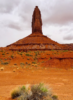 |
| The butte seen from the north side |
At 2.7 kilometers, at a spot between the two mittens, the trail merges into a sandy jeep road. After just fifty meters, the trail leaves the Jeep road to the left (northwest) and continues circling the West Mitten.
 |
| At the Jeep road |
You'll see signs of a Navaho homestead out in the valley, along the jeep road. Keep your eyes open for wild mustangs that roam the area! I saw one near the trailhead.
 |
| Mustang along the trail |
At the 4.3 kilometer mark, the trail dips into a wash for a short time. There are junipers lining the wash, and if you're there in the springtime, the desert floor will be full of wildflowers (and probably caterpillars!). Keep your eyes open for this unique biotope.
 |
| Desert wildflowers |
When you get back to the loop junction, just turn right to follow the trail back the way you came, heading uphill and circling up beneath the campground.


No comments:
Post a Comment