Saturday 23 October 2010

Auckland Devonport, New Zealand Running Route

Length: 5.5 km (3.4 miles), terrain contains two hills of 40- and 50-meters

Auckland running routes:
Auckland Devonport island run
Auckland Domain park and Parnell route

For more running routes, see Route List

If you ever spend time in Auckland (oh, lucky you, if it ever happens!), then you definitely have to get out and explore some of the islands out in bay: Waiheke, Rangitoto, etc., all reachable using the ferries. The closest one, Devonport, isn't really an island, but a peninsula, but still has an island flair. This is my favorite place to jog in Auckland: the ferry ride itself is fun, then you have a view of the city and the other islands, some hills, a fort and a really nice beach to swim before you put your shoes back on and head back to the ferry landing.

NOTE: see the Destinations Tips page for tips about spending your free time in this great town!
Off we go to Devonport...
The Devonport Route
Getting there: it's a short but interesting ferry ride from the Downtown Ferry Terminal. Once you disembark, at Devonport, just jog along the water to the north, keeping the water on your right side. Most of the way is waterfront park along King Edward Parade. Keep going past the Masonic Tavern (or stop in, as I have done), heading towards the hilltop fort at North Head. 
Masonic Tavern with Mt. Victoria in background
You have to turn left before the hill, onto Cheltenham Road, with the cricket fields on your left. Then turn right at the second right, Takarunga Road, going up the hill to the World-War-II-era fort.
Heading towards the North Head fort
If you like old cannons and stuff like that, you'll be fascinated by the fort. Plus, you've got great views across the bay. Exiting the park at the north end lets you come right down to Cheltenham Beach. The beach is great for swimming, and is lined with beautiful homes and has a beautiful view of the graceful cone of volcanic Rangitoto Island. You might even want to make a trip up the side-streets like Macky Ave. and Oxford Terrace, just to see more of the neighborhood.
Typical Devonport
Continue running with the water to your right side to the west end of the beach. The beach ends at Cheltenham Road again, where you turn left to begin looping back to the ferry landing.
The view of Auckland from Mt. Victoria
Turn right on Albert Road and run through this nice neighborhood until you see the trees on your left with the big hill behind it, Mt. Victoria Reserve. Run up the hill to get a great view of Auckland.

Keep running south, down the hill, and you'll come out of the reserve on Victoria Road, Devonport's short main street. It's a laid-back place, full of restaurants and pubs, and a great place to spend the evening. The ferry landing is at the east end of the street.

London Greenwich, UK Running Route

Length: 5 km (3.1 miles), terrain hilly

London Running Routes:
Best London Running Routes: Overview
Thames Embankment
Docklands-LimehouseRegent's Canal and Camden Town  
Hampstead Heath  
3-Parks Route: Hyde Park, Green Park, St. James' Park  
Regent's Park  
Hyde Park   

Chelsea
Heathrow Harmondsworth Moor  
Greenwich 

Richmond Park
Notting Hill
Victoria Park
Wimbledon Common Trail Run
Royal Docks/ExCeL Route 
Kew / Brentford Thames Run  
For more running routes, see Route List. 

Pictures by Chris Hauser. Thanks!

If you've seen enough of central London, one great place to go is Greenwich. It has a very Victorian, small-town feeling, with an imposing old Naval College campus, historic pubs, the Maritime Museum, and the rolling hills of Greenwich Park, with the famous observatory on the hilltop.

NOTE: see the Destinations Tips page for tips about spending your free time in this great town!
 
Getting to Greenwich takes a while, but it's simple enough: go there with the Docklands Light Railway (DLR), or one of the commuter trains, or -- even better -- take the Thames Clipper ferry from one of the landings in central London: it's the most unique way to see the waterfront.

The Greenwich Route
We'll start in the heart of the old village, at the Cutty Sark DLR station. The river is just a hundred meters away, opening up from the station onto a big square. The square has returned to its former glory: a few years ago, the famous Cutty Sark clipper ship sitting there in drydock way gutted by a fire, and it was covered in plastic tarps for a long spell, a sad shadow of its former glory. But it has been beautifully restored again. The Gypsy Moth yacht also used to sit there, the first boat to be single-handedly sailed around the world. But the Cutty Sark and the view of the river and the Docklands across the way are worth the stop. There is also an entrance to the old foot tunnel to the Docklands right there. But tunnels aren't terribly scenic from the inside...
Entrance to the pedestrian tunnel under the Thames
So we'll run towards the right along the footpath, with the river directly to our left, and the Royal Naval College on the right. The buildings are grand monuments to the British Empire, although they're not used by the Navy anymore. London is trying to put them to good use, with music and arts colleges occupying some of the buildings. At the far end (east) of the campus, you'll find one of the most historic of English pubs, the Trafalgar, where all the Navy heroes once drank their rum. Make sure to return sometime with appropriate clothes to have a pint and to soak in the riverfront atmosphere.

From the Trafalgar, turn right to head up Park Row, with the college on your right. After crossing Romney Road, you will have the National Maritime Museum on your right. You can gaze at the few maritime artifacts in the yard if you want.

Otherwise, continue through the park gate, going straight uphill towards the Royal Observatory. The 0 Meridian is drawn on the ground there, and it even divides the building and a doorway down the middle. In the old days, ships waited in the river to watch for the red ball to be dropped down the pole so they could set their chronometers to exactly 12 o'clock. Your digital watch probably doesn't need the extra help.
Meridian Line at the observatory
Now you can loop clockwise through the park, first heading to the left (east) along the hilltop among the amazing old chestnut trees. In the back-left (southeast) corner of the park is a nice fenced-off gardens to run through, called the "Wilderness", with some impressive cedar trees.
View from the park: Maritime Museum, then the college, with Docklands in background
Loop around the back (south end), running westwards. Then follow the edge of the park along the west side (turn right to head north).

Before the path starts going downhill, you'll come to a small exit between some interesting old houses. As nice as the park is, here is a chance to see more of this nice Victorian town.

Go out through the park gate to the street, Croons Hill, turn right and run downhill for a few blocks till you get to King George Street.

Turn left here to run through the old Victorian row houses once used by Navy officers and cadets.

Turn right on Luton Place and then, turning right again at the Prince Albert pub, you just need to follow Royal Hill down to where it ends at High Road.

Now turn right to head back the last 250 meters to the starting point, passing the old Greenwich Market on the right side, just after the church.

Sydney North Shore Running Route

Length: 13 km (8.1 miles), if you run back the same way from Mosman Bay, terrain hilly
(If you take ferry back, you cut the distance in half!)

Sydney Running Routes:
Best Sydney Running Routes: Overview
Central Businesss District (CBD)  
Harbour north shore  
South Head and Watsons Bay  

Bondi to Coogee Coastal Run
Manly Beach Run
Centennial Park Run
Photos by Jessica Hauser 

Check the Routes by Country/City page for more great routes!

If you have the good luck to be going to Sydney, it's time to get down on your knees and thank the Great Spirit or your own great fortune that you will experience this most livable of cities. Sydney combines gorgeous scenery, nice weather, lots of water and beaches, and a laid-back lifestyle that will captivate you from the first minute you get there. And, of course, it's loaded with great jogging routes.

NOTE: see the Destinations Tips page for tips about spending your free time in this great town!
 
The harbour (that's what they call the fiord-like bay) provides endless vistas of nice, waterfront neighborhoods, sailboats tethered in coves, with cliffs, rocks and beaches. And the ocean coastline north and south of the harbor mouth also provide a stunning mix of cliffs and beaches.

I have worked there a few times, on one project for a whole month. There are a hundred great routes: just get out there and run, and you'll find your heart flying like a bird. But here's a route that not everyone discovers: running along the North Shore of the harbour. It provides a constant change of beautiful homes, parks, boats and rocks, with a view of the main city across the bay, with the opera house and the Harbour Bridge crowning the horizon.

You can run the route, then run back the same way, or simply take a ferry home at one of the various ferry landings (a great experience in itself!). The point of the run is to follow the water, zigzagging along the coves.
View of central Sydney from North Shore
North Shore Route
Personally, if I were in the Central Business District, I'd just run across the Harbour Bridge and enjoy the great view from up there on the way to the North Shore. But let's assume that you got to Milson's Point at the foot of the bridge yourself (there is a ferry landing right here, just a quick ride from the main Circular Quai ferry terminal across the harbour). So you now find yourself standing next to the public pool at the entrance to the Luna Park amusement center.
Kiribilli side street
Looking at the water, just turn to the left, following the footpath, with the water on your right. The path will end in a neglected park very quickly, and you'll need to go uphill to the next street, Kirribilli Ave. Follow it to the right, and you'll run by the British Governour General's mansion-house, and continue around on Carrabella Street, keeping as close to the water as you can by going downhill on Peel Street to Elamang Avenue. At the Sydney Flying Squadron (home of the wild sailors who invented the notorious Australian skiffs, not pilots!), cut across Milson Park at the end of the little cove.

Run northeastwards on Hipwood, then along Clark Road, up and over the promontory separating the cove from Neutral Bay. You will run right to Neutral Bay. Cut across its park right at the water, and go uphill again on Kurraba Road.
Governor General's mansion in Kiribilli
Turn left at Billong Road, which quickly connects to Shell Cove Road, where you turn left again. If you see the footpath going down to the park at the end of the cove, you'll have a nicer route. Otherwise follow the road around the end of the cove and hit the park from there.
Entrance to the Cremorne footpath
Once in the park at Shell Cove, you'll begin my favorite part of the trip: the Cremorne neighborhood. The houses are pleasant and the landscaping sloping down to the shore is stunning.

Just follow the footpath along the cliff overlooking the water. Once you get to the south end, at Cremorne Point, there's a small park where you can climb down the ladder at the lighthouse, and amaze yourself with the rock formations carved out by the winds. You can even cool off with a swim here, but be careful of cutting yourself on the mussel-covered rocks.
Cremorne jungle paradise
Heading north along the shore on the east side of the Cremorne peninsula, the scenery gets even better: residents have lovingly created jungle gardens along the water, and you can explore their footpaths as you please. Don't miss it! You'll never want to leave your newly found jungle paradise.

Once you do finally get moving again, heading to the head of Mosman Bay, you run through a beautiful woods, which ends at a marina and ferry landing. Either turn around here, or take the next ferry back, or continue on past Serius Cove to Taronga peninsula, where you can visit the great zoo, or take a ferry from there.
View of Mosman Bay from the north end of Cremorne

Lisbon, Alfama, Portugal Running Route

Length: 5 km (3.1 miles), terrain hilly

Lisbon Running Routes:
Best Lisbon Running Routes: Overview
Park of Nations (Oriente)
Ancient Alfama  
Elegant Lisbon Downtown  
Belem World Cultural Site  
Cool Bairro Alto
   

For other running routes, see the Route List

Lisbon is the only European city that I know that has an old town made of narrow alleyways running up and down a hillside, full of stairs, little plazas and life the way it was a hundred years ago: the Alfama. The neighborhood goes back at least to the Roman days. And although the streets are narrow, dark and rundown, I feel safe there. The Portuguese might be poor, but they are honest and hard-working. The neighborhood has experienced an increase in tourism in recent years, but it's still a real, living neighborhood.

NOTE: see the Destinations Tips page for tips about spending your free time in this great town!
In the Alfama
And bordering the Alfama, on the same hill, are the stalwart cathedral (the Se) and the castle (Castelo de Sao Jorge). You can easily experience it all in one good jog, if you don't mind the climb. Even if you don't like hills, just walk the steep parts.

The Se
The Lisbon downtown, the Baixa, is situated in a valley between two hills, with the Bairro Alto to the south, and the Alfama to the north. So you can easily get to the Alfama from the city center. There is also a wonderful old streetcar line (the 12 and 28 lines) that goes right up the hill between the Alfama and the castle. The Alfama lies at the lowest part of the hillside, towards the river.
The streetcar line in the downtown
If you start at the Rossio plaza, jog down the Rua Augusta pedestrian street until you reach the intersection of Rua Conceicao, and turn left, following the streetcar line. You'll see the street rising up the hill ahead of you. Run uphill, pass the cathedral, till you get to the open viewpoint over the Alfama rooftops at the Miradouro de Santa Luzia. You can see the maze of alleyways winding through the neighborhood below you.

You can now go down the stairs, and wander up and down a few of the the alleyways to soak up the atmosphere: the clotheslines hanging overhead and the chirping canaries, the kids kicking soccer balls against the walls.

Then come back to the Miradouro, and cross the street, taking the side-street to the left of the decorative arts museum. There are signs guiding you up to the castelo. If you get there before the 6 p.m. closing time, you can buy a ticket and continue running in the wide-ranging castle compound.
View from the castelo
Otherwise, the little neighborhood in front of the castle gate is worth a little loop, running down Rua de Santa Cruz do Castelo.

From here, you head the same way back to the Miradouro, and follow the streetcar line back to the center (or buy a ticket and ride back, an experience similar to the San Francisco cable cars!).

Manchester, Worsley, UK Running Route

Length: 5 km (3.1 miles), terrain flat

Manchester running routes:
City center route
Salford Quays route

Rochdale Canal route
Worsley route
For more running routes, see Route List.  
Worsley is a suburb of Manchester, located on the western edge of the metropolitan region, past the slummy Eccles area. If you're in Manchester and need a break with nature and beautiful scenery, head to Worsley. It's a community of half-timbered houses placed around one of England's oldest canals and their narrowboats. Worsley was once one of the pioneers of the industrial revolution, with coal mines, metalworking and railroads, but you would never guess it when jogging the area today.
Home in Worsley

Worsley route:
Start the run at the center of the old village, Worsley Brow, located near the M60 exit at A572. This places you in the middle of the old houses and the Bridgewater Canal. You could just jog up and down any of the streets here, and you will be guaranteed to be amazed at the scenery. My preferred route goes like this:

Turn up Worsley Road, where the woods and cliffs above the pond start. The cliffs conceal the entrance to 17 miles of underground canals, but you can't get in there, so no need to get out your flashlight. Turn left at the first street, going uphill on Mill Brow. The street ends soon at a woods, and you will continue on a footpath, with a beautiful valley on your left.

Continue on the main footpath through the woods until you finally come to another big footpath that has more of a dirt-road character. Turn right here. This path was once a railroad bed. You can continue along this path for a couple of kilometers to Monton Green, with the Worsley Golf Club on your left side, and fields to the right.
Narrowboats along the Bridgewater Canal

At Monton Green, you can return the same way, or turn right, cross the canal and then turn right to follow the canal back to Worsley again. Back in Worsley, take some time to jog up and down the streets around the canal at Barton Road and The Green. Even the pubs are scenic!
One of the Worsley pubs

Friday 22 October 2010

Düsseldorf Gerresheim, Germany Running Route


Length: 8 km (5 miles), terrain hilly

Düsseldorf Running Routes:
Königsallee/Altstadt/Rhine  
Gerresheim hills  
Both Sides of the Rhine  
Rhine Harbor Route  
Stadtwald forrest run  

See the other running routes here! 

Düsseldorf is a medium-sized city, with a variety of great jogging routes. You can head along the Rhine River, head through the beautiful beechwood hills of the Stadtwald forest, or find similar country in the Gerresheim neighborhood, on the north edge of the city. I like Gerresheim because it combines a beautiful village center with wooded hills and valleys just east of the neighborhood.
Typical ravine in the beech woods near Gerresheim
NOTE: see the Destinations Tips page for tips about spending your free time in this great town!
 
You'd never guess that you are on the edge of a real city. Gerresheim was once a separate village, and it still preserves some of the small-town feeling. I was back in Düsseldorf a couple of months ago, and the idea of running in Gerresheim pulled me there like a magnet.

Gerresheim Route
GETTING THERE: You can get there easily by taking the 703 streetcar, or even the S-Bahn commuter train, if you don't have a car. If you take the 703 streetcar, get out at Gerresheim Rathaus (town hall). You are then right there in the center of the village. The 709 and 713 streetcars also go to Gerresheim, but then you have to get out at Gerresheim Krankenhaus, the end of the line, and jog a kilometer down Gräulinger Straße.

From the Rathaus, jog the 2 blocks eastwards down Neussertor to the old, romanesque St. Margarete Church. There is a beautiful, quiet old square on the south side of the church.
St. Margarete
Now, turn right and go diagonally southeast through the square onto Steinweg.

Head straight across this square
Run south on Steinweg, first going past the old market with its twin rows of sycamore trees and boules courts. Steinweg soon ends at Quadenhofstraße. At Quadenhofstraße, turn left, and the street will curve to the right, taking you south again.
Gerresheim market boules players
You'll see the wooded hill along your left side. Right at the curve, you'll see a place where they sell gravestones for the nearby cemetery.

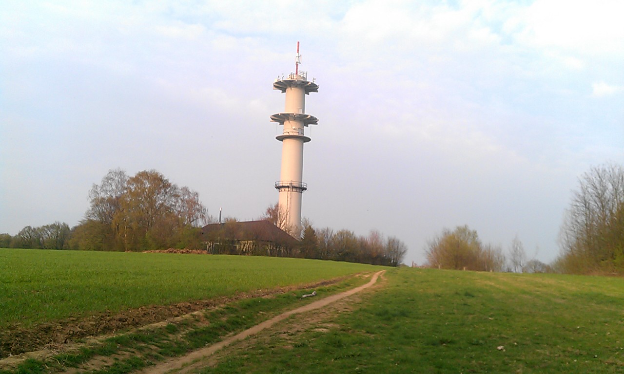
Turn in here, just before the gravestones, and jog the path up to the top of the hill. The last part is pretty steep! At the top, you'll come out to a farm field with a tall radio tower on the hilltop. Note down its silhouette: that cylinder-shaped tower will be your landmark to help guide you home.

The radio tower: remember this silhouette!
We will now run northwards along the hilltop ridge, before turning right (eastwards) and running downhill to the next valley, before finally heading south again. We'll head uphill again at the radio tower from the other side again at the end.
The first part of the trail is totally unmarked. But don't worry, if you follow these directions, you should be fine. And if you get lost, what better spot to be running in circles than in this green paradise?

Just turn left and follow the edge of the field. At first, there is woods to your left, then another field opens up on the left side. Just follow the little unmarked path as it curves around to the right. 
The unmarked path
When the path runs into the paved road, turn left. 

When you come to Dernbuschweg on the left, you come to your first farmhouse, the Trotzhof. There might be a few cars on the street here, but we'll soon get off this street.
Trotzhof farm: in 200 meters, turn right
After 200 meters, turn right onto the little dirt road with the "dead end" sign, Schäperhofweg. Notice the trail markers on the sign for the "D" and the diamond-shaped symbol. 
This is the way east to Schäperhof!
We'll now follow the dirt road across the fields and then downhill to Schäperhof farm.
The way downhill: watch those rocks!
When you get to the farm, just continue through the gate and go right through their front yard. Strangely, this is the public footpath, with the trails continuing.
Keep going straight past the Schäperhof farmhouse. Note the trail markers
Just after their barn, the trails turn to the right and go down across the little stream that runs through Rothäuser valley.
I came across this shepherd and his goats near Schäperhof
When you cross the stream, the paths turn right and begin heading south. We are now at the half-way-point of the run, heading back home. The path gets pretty swampy at times, but normally people have thrown enough branches over the deep, black mud to make them passable without sinking in to your knees.

You will soon come to a series of ponds along the stream. At the last pond, the path sudden turns left to up over the next hill instead of following the water.
Along the ponds
Follow the way uphill, as it curves to the left. At the first little path that goes down to the right, take it! We are now leaving the marked paths again. The small, unmarked path goes downhill, to the right. It will come down to the stream again, where you cross the water on a willow-tree-lined path.

On the other side of the stream, at a farmhouse where the farmer has a love for old-timer cars and motorcycles, turn left and take the dirt road to the next farmhouse just a few hundred meters south.

Just before the fenced farmyard, turn left on the little path that heads along the fence, uphill towards the radio tower again. Another long climb!
Way back uphill to radio tower
At the hilltop, run straight past the tower on the little path that goes between the fields. This heads right to the spot where you first saw the tower. Now follow the path downhill through the woods, the same way that you came, and follow it back to the start of the run.

Plauen, Syratal trail, Germany Running Route

Click here for route map

Length: 7 km (4.3 miles) for the run to Holzmühle and back, about half that for the run to Stadtpark.

For more running routes, see Route List.

Plauen is located in the green hills of Vogtland, Germany, on the Czech border. The town, like all those in the region, was once a powerhouse of the textile industry, full of mills powered by the quick-moving mountain rivers. The 20th century, though, saw a steady decline of industry and population, a downward spiral continuing to this day.

The area was part of communist East Germany, and a lot has been restored and redeveloped since reunification, but many buildings stand empty: there's nobody there to move into them. It's the same sad story you'll find in many declining industrial towns.

But a lot of the old town survived the bombing raids of the last year of World War II, and the town is beautifully nestled among hills and rivers. The people are down-to-earth, and they were the first brave pioneers to successfully stage a protest against the East German regime, which began a process which later brought it down.
Plauen Rathaus (townhall)
I was working there again a couple of weeks ago, and found a great trail for evening runs:

The Syratal

The Syratal (Syra Dale) follows the Syra creek westwards from the Plauen downtown, heading upriver, curving northwards. The creek actually runs under the main part of the town center, hidden away in a tunnel. Starting out at the Vogtland theater at the Postplatz, you can run out Dobenaustraße, which soon goes under the Friedensbrücke bridge (at the time it was built, it was the world's longest single-span bridge, and out along the park with the kids' mini-train on Hainstraße. Syra creek soon shows up, flowing next to the street, and after another block, you pass the last houses in town.

At this point the street ends, and the way continues as a bike/pedestrian path. You can take either fork in the path: the right-hand way leads to nearby Stadtpark, a pleasant park to loop through, with a pond, playgrounds, cafe, etc. You could just head back to town again, following the way you came, and you would do about 5km.
The Syratal
Or take the left-hand fork, keeping to the left-side of the stream. This will take you out into the beautiful Syratal. You'll soon run under the old stone railway bridge, with wooded hills bordering the dale on either side. The stream meanders beautifully here. You can continue running the main trail all the way to the Holzmühle mill. If you turn around here, you will do about 10km.
Syratal Railway Bridge, 100 years old
You could also continue from the Holzmühle, going either left or right, and continue on the various intersecting trails as far as you like.
Syra at the Holzmühle